Disaster Management · TEE · papers
Q5B · Discuss in detail the Cordon-Off Zones. Elaborate their significance citing relevant …
2023-05-04 · Semester VI final
Actual older TEE paper · 100 marks · Q1 compulsory; any four of Q2–Q7
Q5B. Discuss in detail the Cordon-Off Zones. Elaborate their significance citing relevant examples in Disaster Management for Floods. [10 marks]
Answer
A river-flood cordon is a controlled access boundary around assessed inundation, unstable banks, damaged crossings or other flood hazards. It follows the changing flood footprint and safe routes, not a universal circular radius.
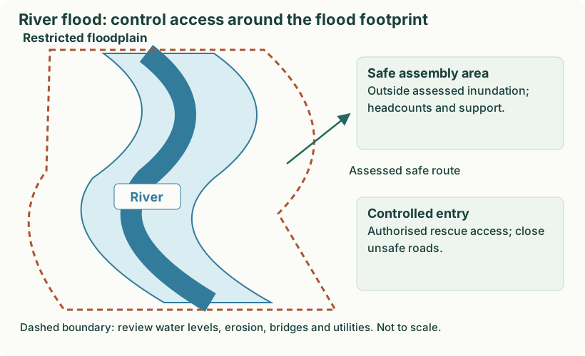
Diagram: River flood: control access around the flood footprint. Labels: River flood: control access around the flood footprint | River flood: control access around the flood footprint | Restricted floodplain | River | Safe assembly area | Outside assessed inundation; | headcounts and support. | Controlled entry | Authorised rescue access; close | unsafe roads. | Assessed safe route | Dashed boundary: review water levels, erosion, bridges and utilities. Not to scale.
- Identify the restricted area. Use forecast and observed water levels, inundation maps and field reports. Include erosion, damaged bridges, electricity and contamination where relevant.
- Control access. Place barriers and trained personnel at unsafe roads and crossings. Permit only authorised, suitably equipped teams through managed entry points.
- Preserve safe evacuation and rescue routes. Keep public evacuation and emergency access clear; reassess routes as water levels and bridge conditions change.
- Organise safe support outside the cordon. Locate reception, headcounts, first aid, shelter coordination and command outside the assessed flood danger.
- Review and reopen safely. Move the boundary as the flood footprint changes. Reopen only after competent checks of water, roads, structures and utilities; receding water alone is insufficient.
Example: a riverside road and damaged bridge are closed while an assessed dry route leads residents to a designated safe assembly point. This illustrative layout explains the function of the cordon; it is not a map or a prescribed evacuation distance.