Disaster Management · TEE · papers
Q4B · Explain in detail with respect to its causes and stages of Disaster management the ca…
2023-12-04 · Semester V final
Actual older TEE paper · 100 marks · Q1 compulsory; any four of Q2–Q7
Q4B. Explain in detail with respect to its causes and stages of Disaster management the case study of “Nisarg Cyclone”. [10 marks]
Answer
- Event and setting: Cyclone Nisarga made landfall near the Maharashtra coast on 3 June 2020.
- Causes and vulnerability: A tropical cyclone brought strong winds and rain to exposed coastal settlements and infrastructure.
- Impacts: Damage to roofs, trees, power networks and livelihoods; rain and access problems complicated response.
- Response and recovery: Official forecasting and warnings supported protective preparations and evacuation; agencies then assessed damage and restored essential services.
- Lessons: Translate forecasts into local action using mass communication plus last-mile outreach; prepare shelters, protect lifelines and support recovery. Distinguish what authorities should do from a claim that each particular action is documented.
Definition. Cyclone warnings provide advance information on likely coastal effects, allowing authorities and communities to prepare, evacuate and protect essential services.
| Stage | Usual lead time in the lecture | What it supports |
|---|---|---|
| Pre-cyclone watch | About 72 hours before adverse weather | Initial readiness and review of plans. |
| Cyclone alert | About 48 hours before adverse weather | Mobilise resources, shelters and evacuation arrangements. |
| Cyclone warning | About 24 hours before adverse weather | Implement protective action based on the latest official advice. |
| Post-landfall outlook | About 12 hours before landfall | Prepare inland areas for expected track and adverse weather after landfall. |
The name post-landfall outlook describes the period forecast, not the time at which it is issued. Its 12-hour lead is before landfall. Forecasts can be updated as the storm develops. Cyclones can be forecast days ahead, with uncertainty; the claim that advance forecasts are impossible is incorrect.
Before impact
Follow official warnings; move from unsafe coastal areas to designated shelters when instructed. Arrange transport for people needing assistance, carry essential medicines and documents, secure loose objects, and prepare backup lighting and communication. Fishermen should follow official sea warnings.
During and after
Remain in a safe shelter away from glass, avoid travel and floodwater, and follow official instructions. A temporary calm may be the eye; it does not mean the storm is over. Wait for official clearance before returning; avoid damaged structures, lines and contaminated water.
- Warning and last-mile communication. Use official forecasts, clear action messages and several communication channels. A forecast must reach fishers, visitors and people without smartphones, with enough time and support to act.
- Shelters and evacuation access. Provide accessible shelters outside surge and flood zones, linked by reliable routes. Practise transport, headcounts and support for people needing assistance so that shelter capacity becomes usable protection.
- Resilient buildings and lifelines. Strengthen roof connections and protect power, water and communication systems to appropriate standards. Hospitals require backup services and protected equipment to keep functioning during response.
- Risk-informed coastal land use. Use surge and flood maps to control exposed development and locate critical infrastructure safely. Protect mangroves and appropriate coastal vegetation as part of a wider protection system, not a guaranteed barrier against every surge.
Apply the management stages to this case
| Stage | Case-based application — not an action-by-action historical log |
|---|---|
| Mitigation | Reduce wind and flood vulnerability through suitable construction, drainage, safer siting and protected lifelines. |
| Preparedness | Use forecast information, official alerts, evacuation arrangements, shelters and trained personnel before landfall. |
| Response | Protect life, restrict dangerous areas, coordinate trained rescue and provide urgent care and essentials. |
| Recovery | Restore services and livelihoods, assess damage and rebuild with reduced vulnerability. |
Nisarga formed through tropical-cyclone processes over the Arabian Sea: warm ocean water, moisture, favourable circulation and sufficiently low disruptive vertical wind shear supported organisation. The detailed formation diagram explains these processes; do not attribute a particular loss solely to one factor without evidence.
Definition. A cyclone is an atmospheric circulation around a low-pressure centre. A tropical cyclone is an organised rotating storm over warm tropical or subtropical waters, with strong winds, rain and potentially storm surge.
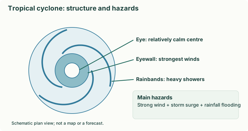
- Warm ocean water supplies moisture and energy by evaporation. Typical favourable sea-surface temperatures are around 26–27°C or higher over adequate depth.
- Warm moist air rises; condensation releases latent heat, supporting further rising motion.
- Air flows towards the low-pressure centre. Earth’s rotation helps organise the circulation; systems do not usually form right at the equator.
- With favourable conditions such as sufficient moisture and limited disruptive vertical wind shear, the system organises and intensifies.
- A mature system may develop an eye surrounded by an eyewall. It weakens when it loses favourable ocean energy or encounters hostile atmospheric conditions.
| Part | Meaning |
|---|---|
| Eye | Relatively calm central region with descending air in a well-developed cyclone. |
| Eyewall | Ring of intense convection; strongest winds and heavy rainfall are commonly found here. |
| Rainbands | Spiral bands of clouds and rain around the centre. |
| Track | The path followed by the storm; forecasts have uncertainty. |