Disaster Management · TEE · papers
Q5B · Draft the hierarchy chart for Flood Management in India and explain the role of each …
2025-12-10 · Semester V final
Actual TEE paper · 100 marks · 3 hours · Q1 + any four of Q2–Q7
Q5B. Draft the hierarchy chart for Flood Management in India and explain the role of each component in brief. Also, explain how inter-linking of rivers can reduce the risk of River Floods. [10 marks]
Answer
Flood management in India combines central technical support and coordination with state planning and implementation. The lecture identifies the following flood-specific organisations; district and local services turn their plans and warnings into action.
1. Flood-management organisation chart
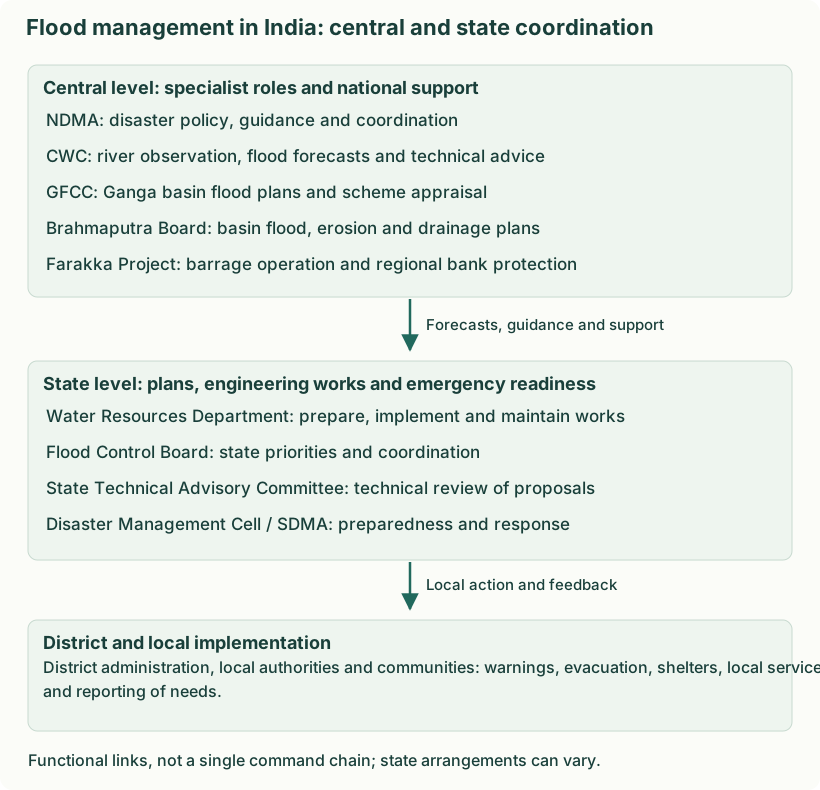
2. Central-level components and their roles
| Component | Role in flood management |
|---|---|
| National Disaster Management Authority (NDMA) | Provides disaster-management policy and flood-risk guidelines; supports preparedness, coordination and risk reduction across agencies. |
| Central Water Commission (CWC) | Observes river levels and flows, issues flood forecasts and gives technical advice/appraisal for flood-management schemes. Its forecasts help states decide when to warn and evacuate. |
| Ganga Flood Control Commission (GFCC) | Prepares and coordinates flood-management planning for the Ganga basin; appraises and monitors relevant schemes so measures in one part of the basin account for other affected areas. |
| Brahmaputra Board | Develops basin plans and investigations for flood control, bank erosion and drainage in the Brahmaputra and Barak systems and its assigned region. |
| Farakka Barrage Project | Operates and maintains the barrage and associated works and undertakes riverbank/anti-erosion protection within its assigned area. This is a regional project role, not control of all Indian rivers. |
3. State-level components and local implementation
| Component | Role in flood management |
|---|---|
| State Water Resources / Irrigation Department | Surveys local problems, prepares and executes flood-control and drainage schemes, and maintains works such as embankments and channels. |
| State Flood Control Board | Sets or reviews state flood-management priorities and coordinates proposals and responsible departments under the state arrangement. |
| State Technical Advisory Committee | Examines engineering proposals and their technical soundness before projects progress through the applicable approval process. |
| State Disaster Management Cell / SDMA | Coordinates preparedness, warnings, resources and emergency response with state departments and districts. |
| District administration and local authorities | Communicate actionable warnings, manage evacuation and shelters, maintain local services and report damage and resource needs. |
Example of the connection: CWC forecasts a rising river; the state department and district administration assess exposed areas, check protection works and communicate evacuation instructions. A basin-planning body supports longer-term schemes, while the district manages local action.
4. How river interlinking may help, and its limits
- Possible diversion. A suitably designed transfer can divert part of a high flow to a basin with spare capacity. The receiving basin must not itself be flooded.
- Storage and timing. Reservoirs and detention associated with a scheme can hold some inflow and release it later. Benefits depend on available storage and forecasts, not merely the existence of a canal.
- Coordinated basin operation. Operating rules, monitoring and communication can reduce poorly timed releases and support balanced water use.
- Limits and safeguards. Conveyance capacity, extreme rainfall, ecological effects, sediment, social impacts and downstream risk require assessment. A transfer can shift risk rather than remove it.
- Mountain flash-flood limitation. Short, intense rainfall, debris flows and slope failures such as those in Uttarakhand require local and basin risk measures. It is not established that river interlinking would have prevented the 2013 disaster.
Organisation list: supplied M2 PPT, pp. 101–102. Role details: Ministry of Jal Shakti on flood management; Farakka Barrage Project functions.