Disaster Management · TEE · papers
Q6A · Describe the role of GIS in training and conducting drills considering any one type o…
2026-05-15 · Semester VI final
Actual TEE paper · 100 marks · 3 hours · Q1 + any four of Q2–Q7
Q6A. Describe the role of GIS in training and conducting drills considering any one type of natural disaster [10 marks]
Answer
Consider a river-flood evacuation drill. GIS helps convert a general plan into a realistic exercise for actual places.
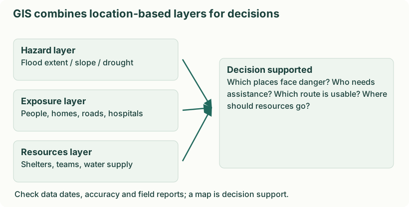
Diagram: GIS combines location-based layers for decisions. Labels: GIS combines location-based layers for decisions | GIS combines location-based layers for decisions | Hazard layer | Flood extent / slope / drought | Exposure layer | People, homes, roads, hospitals | Resources layer | Shelters, teams, water supply | Decision supported | Which places face danger? Who needs | assistance? Which route is usable? Where | should resources go? | Check data dates, accuracy and field reports; a map is decision support.
- Construct a scenario. Show likely flood extent and depth and identify settlements that would need evacuation.
- Map people and routes. Locate schools, hospitals, people needing assistance, roads and bridges; identify bottlenecks and alternate routes.
- Select safe destinations. Check shelter location, accessibility and capacity and avoid routes crossing the forecast flood zone.
- Allocate teams and resources. Assign wardens, transport, first-aid points and communication responsibilities to mapped areas.
- Rehearse changing conditions. During the exercise mark a simulated bridge closure and require teams to select a safe alternative using the shared map.
- Evaluate performance. Record movement times, coverage and unresolved assistance needs; update maps and plans. A shorter evacuation time alone is not success if people were left behind.