Disaster Management · TEE · papers
Q4A · Discuss in detail with a neat sketch Risk Mapping and explain in detail the four step…
2023-05-04 · Semester VI final
Actual older TEE paper · 100 marks · Q1 compulsory; any four of Q2–Q7
Q4A. Discuss in detail with a neat sketch Risk Mapping and explain in detail the four steps of Risk Mapping. Also elaborate in brief the significance of Risk Mapping. [10 marks]
Answer
Definition. Risk assessment identifies hazards and evaluates exposure, vulnerability and capacity to understand possible losses and priorities. Risk mapping represents that information geographically.
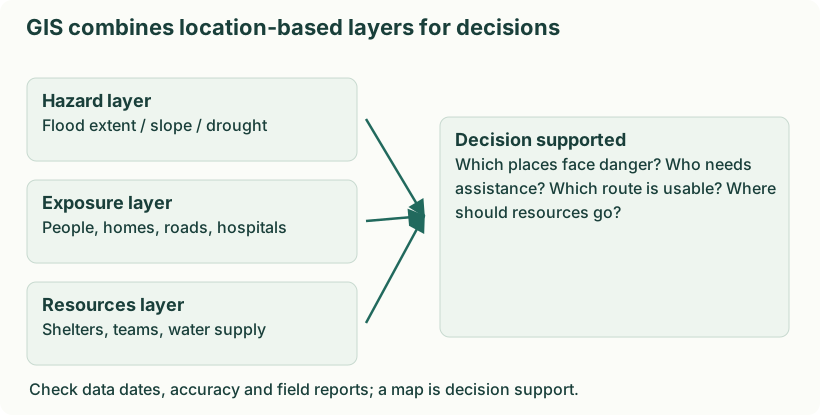
Diagram: GIS combines location-based layers for decisions. Labels: GIS combines location-based layers for decisions | GIS combines location-based layers for decisions | Hazard layer | Flood extent / slope / drought | Exposure layer | People, homes, roads, hospitals | Resources layer | Shelters, teams, water supply | Decision supported | Which places face danger? Who needs | assistance? Which route is usable? Where | should resources go? | Check data dates, accuracy and field reports; a map is decision support.
- Identify risk: determine what can happen, where and to whom. For a flood, gather past inundation, low ground, river and settlement data.
- Assess risk: examine likelihood, depth/velocity, people and assets, construction and coping capacity. Rank areas by potential harm.
- Communicate risk: provide understandable maps, warnings and explanations to planners, responders and residents. Include uncertainty and local accessibility needs.
- Mitigate risk: apply zoning, drainage improvements, shelters, evacuation and training; update the assessment after changes.
Analysis and assessment
| Disaster analysis | Damage / needs assessment |
|---|---|
| Explains why and how an event produced losses. | Estimates what has been damaged and what assistance is needed. |
| Investigates mechanisms, vulnerabilities and failures. | Measures affected people, services, losses and recovery requirements. |
| Uses event data, models and causal investigation. | Uses surveys, inspections, inventories and field reports. |
| Supports long-term prevention and improved planning. | Supports relief allocation and recovery priorities. |
This comparison concerns post-disaster damage/needs assessment. Assessment is not restricted to after a disaster: pre-event risk assessments are essential too. Neither word guarantees greater accuracy by itself.